


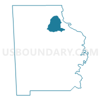
Midway Methodist Church or Assembly, Washington County, Alabama
About
Outline

Summary
| Unique Area Identifier | 523095 |
| Name | Midway Methodist Church or Assembly |
| County | Washington County |
| State | Alabama |
| Area (square miles) | 32.66 |
| Land Area (square miles) | 32.64 |
| Water Area (square miles) | 0.02 |
| % of Land Area | 99.93 |
| % of Water Area | 0.07 |
| Latitude of the Internal Point | 31.56885000 |
| Longtitude of the Internal Point | -88.12849190 |
Maps


Graphs
Select a template below for downloading or customizing gragh for Midway Methodist Church or Assembly, Washington County, Alabama


Neighbors
Neighoring Voting District (by Name) Neighboring Voting District on the Map
- Frankville/Koenton Voting District, Washington County, AL
- Hobson Fire House Voting District, Washington County, AL
- Old Franklin School Site, Washington County, AL
- Springfield Bapt/Bigbee Voting District, Washington County, AL
- St. Stephens Fire House, Washington County, AL